 Filter: Categories of Wisconsin Historical Images
Filter: FORMAT_DIMENSIONS of 25 x 32 cm
Filter: Categories of Wisconsin Historical Images
Filter: FORMAT_DIMENSIONS of 25 x 32 cm

| Date: | 1890 |
|---|---|
| Description: | A map of Wisconsin, eastern Wisconsin and Iowa, northern Illinois, and the Upper Peninsula of Michigan. The counties, cities and villages, and rail lines i... |

| Date: | 1921 |
|---|---|
| Description: | This map has labeled streets and points of interest. Lake Mendota and Lake Monona are labeled. The back of the map includes index of University of Wisconsi... |
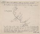
| Date: | 1920 |
|---|---|
| Description: | This map shows a sketch of of the Montreal Rivers and points of interest along the waterway. Includes manuscripts notes in the top and bottom margins. Lake... |

| Date: | 1780 |
|---|---|
| Description: | Map of eastern Massachusetts, Rhode Island, eastern Connecticut, and small portions of New Hampshire and Vermont. It shows the boundaries, counties, citie... |
If you didn't find the material you searched for, our Library Reference Staff can help.
Call our reference desk at 608-264-6535 or email us at: